Saturday, June 20, 2015

Escaping the Heat at North Sandia Peak

The weeks and weekends have seemed rather bleak with recent temperatures reaching into the mid to upper 90s and even breaking 100 today. At first thought, it would appear that hiking or climbing would certainly be out of the question. However, I had forgotten that an island in the sky exists as an escape from the sweltering and draining heat. On the Sandia mountains just east of Albuquerque, that island is everything on the east side of the mountain around 10,000 feet and above. Today, I was lucky enough to have my father and the family dog Trek join me on a short hike to North Sandia Peak. At the end of our day, the exterior thermometer on the car at our parking area read around 78 degrees, and by the time we completed our short drive back to Albuquerque, it had reached 97.
What Albuquerque looks like from 10,000+ feet
To get to this trail, and a variety of other near and short trails, take I-40 east to Tijeras. Exit at Tijeras and head north on NM 14. In the community of San Antonito, you'll turn west onto NM 536 and you'll follow this road all the way up it's ~9 mile length to the parking lot at the top. There are signs in San Antonito pointing to the "Crest Highway" when you are close. The parking lot is right at the base of the towers and requires a $3 parking permit if you park here. The North Crest Trail starts on the northern part of the parking area, on the east side of the towers.
So lively and green!
The plan for today was to hike ~1.8 miles to North Sandia Peak, stopping along the way to find ten geocaches along its length. Most of the caches will be unnamed, as I don't want to accidentally spill out some information that would spoil the hunt for anyone else searching for them.

For those who don't know, geocaching is basically "treasure hunting" with a gps. Caches are containers, some small some large, hidden in various locations for others to find. Some seem random, but most wilderness caches have a purpose of getting cachers to certain locations to see certain views, formations, or features. The caches coordinates are noted, and placed online for other cachers to receive and consequently hunt. Some of these containers contain small goodies to be traded out with other goodies, and some are small enough to only contain a logbook for those who find it. Either way, the challenge of finding them is what makes it exciting.
Small blue cache container somewhere along the NCT
The first quarter mile or so of the hike follows a fence bordering the massive towers that are visible from Albuquerque. Even still, the tree cover is relatively thick, and it feels like you might be hiking in the Colorado or even Canadian Rockies! Much different from the west side and lower elevation hikes, the trail is mostly soft dirt, with a few rocky sections consisting of mostly limestone.
Trek always wants to be the leader
The hike itself is pretty consistent, staying primarily in the cover of the evergreen trees, passing dancing aspens and their fallen comrades. The amount of life up here at this time of year is attractive all on its own, whether referring to animals, plants, fungi, insects...it's all there! We got to see and/or hear Abert's Squirrels, woodpeckers, baby grasshoppers, Peregrine falcons, and some weird and terrifying orange wasp lookalike.
Orange wasp lookalike. Couldn't get it to focus too well before he flew away.
The weather up here was so mild and pleasant, the only discomfort found in the direct path of the sun's rays, which will burn you up here no matter what temperature it is. The trail itself made a very nice stroll, and would be sufficient for hiking all on its own, but the overlooks to be found along the way make it breathtaking. All along this backbone of the Sandias, there are overlooks which provide views of Albuquerque and the Rio Grande Valley, rock formations on the mountain like the Needle and the Shield, and distant peaks like Cabezon, Los Lunas Hill, Ladrones, various peaks in Jemez, and Mount Taylor.
Left to Right: Rincon ridge, the backside of the Needle, and the faintly visible Shield
Since we were caching, we took a side trail that follows the edge of a big limestone cliff directly behind the Needle. The views from this open cliff area are some of the best in the Sandias! You are directly east of the Needle, and the impressive face of the Shield sits directly north across from the Needle, both being separated by a vividly green valley. There are hikes to get to both formations, and into the valley below, but that is for another time ;).
Looking south back toward the towers and where we started
Along the trail to this wide overlook, we were searching for a cache when a couple of Peregrine falcons flew directly above us, creating a sound almost like a wind gust! I wasn't fortunate enough to witness them as I was focused searching, but my father was lucky enough to see it very well. These falcons flew and danced above and around the cliffs almost the entire hike. My dad was watching them intensely, noticing their vertical downward spirals as they shot down to the cliffs.
Dad and Trek posing in the shade
Backside of the Needle and the south side of the Shield
Falcons soaring overhead
After the little side-venture to this cliff band, we veered northeast back to the North Crest Trail. Between this intersection and the spur trail leading to North Sandia Peak lay my favorite cache of the day. Searching for it left me in a mildly sketchy situation, perched up on a small cliff looking for a cache container. However, it wasn't too dangerous and it allowed me to experience a small portion of the area I wouldn't have experienced or seen in this way otherwise.
Views of the Needle not far from my cliffside perch
We continued on, pushing through one of the more exposed sections of trail, with the sun staring right at us as we hiked. The push became steeper as we neared the summit, the grade increasing along with our heart rates and sweat between our backs and packs. That last stretch is always exciting, though, as you know you are so near to the destination. The trail almost seemed to vanish in the overgrowing plants on the side, but Trek seemed to know where he was going and led the way, navigating all the way to the summit of North Sandia Peak.
Northern Sandia crest, viewed from an overlook just west of NSP...SO GREEN!
We found a small spot to refuel and rehydrate just west of the peak proper, which widened up to even greater views of the back knife edge of the Shield, and the bright green slopes of the extreme northern Sandia crest. As you can tell, I LOVE bright green colors, and a lot of the slopes and meadows along the crest certainly bear that lovable hue.
Trek resting with us, enjoying that shade
The hike back was a lot quicker than the way up. Of course, I wasn't stopping every .2 miles to search for a cache on the way back. It was beautiful to see things in a new light, noticing hollowed out trees, a lot more new growth on the evergreens, certain wildflowers we missed on the way in, and some neat trees that appear to have been overtaken by the spanish-moss lookalike known as Old Man's Beard.
Hollowed out tree trunk
New growth...more bright green ;)
All in all, it was a perfect day out on the mountain. The air was crisp, the animals were being vocal, all the caches on my list were found, and it was such a nice temperature. After the heat of the last week or so, I cannot emphasize how greatly appreciated a hike in that temperature was. So for all of you who feel stuck because of the heat, like there isn't a whole lot to do outside in these mirage-inducing digits...head on up to the upper Sandias. Anything from Tree Spring Trail and higher is guaranteed to provide cooler temps and more shade than almost anything else in the immediate Albuquerque area. The trail we did today was a roughly 4 mile hike and wasn't that difficult, and is definitely doable for anyone in semi-decent physical condition. As always though...don't just take my word for it. Get out and go find out for youself!

Sunday, May 31, 2015

Baking in San Lorenzo Canyon

Parking at the mouth of the canyon
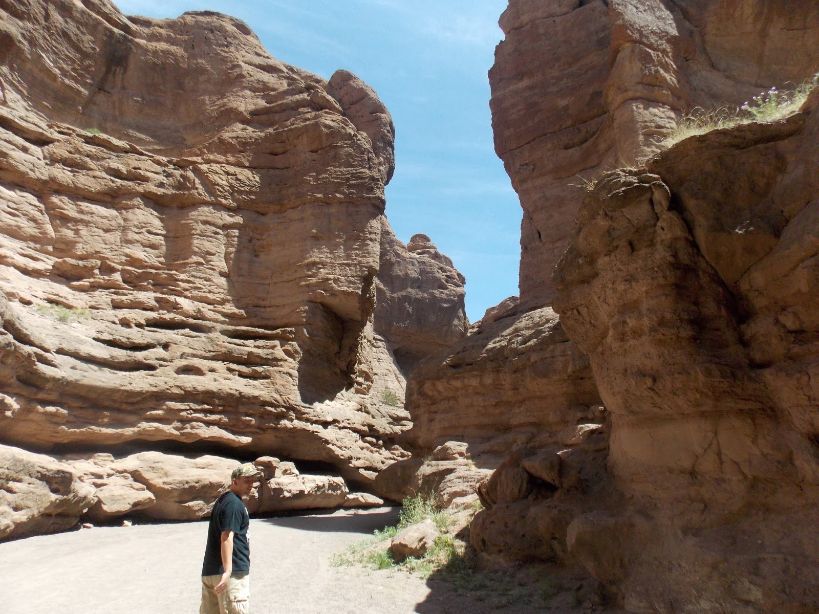
New Mexico is home to so many isolated, hidden gems. With Chavez Canyon up by Abiquiu, the lava tubes in El Malpais, Carlito Springs in the Sandias, San Ysidro Canyon just off of 550, and far too many others to name, there is certainly no shortage of wonders to be found in the state. One more you can all add to your to-do list is a geologic wonderland about an hour and a half south of Albuquerque. With small springs, caves, slots, towers, and more, there is so much waiting to be found by explorers, beginners and experienced alike.
This is another hike outside of Albuquerque itself, though the drive is not terribly far, which is why I am happy to include it in this blog. And I must note that it is certainly worth the drive.

To reach this destination, follow I-25 south and exit at San Acacia, between Belen and Socorro. Take the east frontage road south and go under the interstate at the second underpass. Where the paved road goes south, a dirt road goes west....follow this road. There are countless intersections and side roads, but make sure to stay on this main relatively maintained washboard of a road. After a little over two miles, you reach a cattle guard with a sign for San Lorenzo Recreation Area. Go through the cattle guard and follow this road all the way back to the canyon. The road from here on is very sandy, and meanders in and out of an arroyo. 4WD is not always necessary when the road is okay, but it is recommended, as it would not be hard to get stuck in the sand through here.
Unique erosion in the soft sandstone
You can park in the canyon mouth or drive to the back where house sized boulders block any further progress for vehicles. I personally find it best to park near the entrance of the canyon and walk up through the rest of the canyon, exploring everything along the sides as you go. There are so many side canyons and features to explore, it is not difficult to pass hours and hours exploring them all.
A local bee taking care of business
It's very exposed out here, which makes it ideal for every season but summer and early fall. Brandon and I ventured out today in roughly 80-90 degree heat, which was exhausting but manageable. The many side canyons provided opportunities for shade, and water was a constant focus. Even with the heat, the magnificence and scale of this area make it all worth it.
Brandon walking in shade beneath towering sandstone cliffs
Entrance to one of the many side canyons

Camping is allowed out here away from water sources, and it would be an excellent spot for just that! Though, I am very interested in it for the opportunity to see what desert spiders like to crawl out here after dark. Though there was a lot of evidence of neighborhood spiders, a daddy long leg was all that we saw today.
Looking through to another world
Walking through one of the larger slot canyons
Daddy long legs were certainly not the only thing showing themselves today, though. On our walks and wanderings, we came across a tiny frog, many different kinds of lizards, tarantula hawk wasps, and squirrels that appeared to be almost twice their normal size! Even in this dry, desert environment, life was certainly plentiful all around us.
Towards the back of the canyon, several house sized boulders pile up in the canyon, though they are easy to maneuver around and continue past. Most people tend to end their days exploration here, but there is a small spring just a little farther back in the canyon. I'd heard about this but did not go to see it my first time in the area, and it was a wonderful treat to see today! I was surprised at how well the spring flowed, and it added such color and character to the small area it occupied.
Just above the mini waterfall, all the green on the ground is flowing
Tiny waterfall fed by a healthy spring
It is impossible to show or list everything about this canyon, and it is difficult for me to put into words just how grand and unique this place is. I can only hope that this inspires you to go out and see for yourself. The experience of wandering out here, not knowing what you may find around every corner, is unlike most other areas closer to Albuquerque. I DEFINITELY suggest to pack a cooler, some snacks, and tank of gas, and head out to explore this wonder. If you have questions of direction or anything, feel free to let me know and I will be happy to help. Happy trails!!
Brandon in a small cave up on a hillside
A tower declaring its spot ahead of these walls


Saturday, May 23, 2015

Canyon Hunting On El Cerro De Los Lunas

With sand in my shoes, small cuts along my legs, and red arms, I have had a very successful day of hiking and climbing on a landmark that is most sentimental and beautiful to me...Los Lunas Hill.
Los Lunas Hill, or El Cerro De Los Lunas, sits on the western edge of Los Lunas, NM, a small town about 30-40 minutes south of Albuquerque. Overlooking the entire town, it is host to lots of desert wildlife, various canyons, sand dunes, petroglyphs and even some very spread out and isolated bouldering.

While there are a lot of official trails popping up on the "hill", one of my favorite hikes is the main eastern canyon, one that resembles a big cut or chasm in the side of the hill. After many years, something about this little canyon always brings me back.
Alyssa working up the steep sand bank
To reach this canyon, take I-25 to Los Lunas. Take a right onto main street and head down towards Huning Ranch. Skip the first turn into the community and make the next left onto Huning Ranch Loop SW. You'll pass an elementary school on your right on this road. Follow all the way down and take a right, heading up to park in the southwestern-most cul-de-sac. Basically when you're passing the mailboxes at the bottom of the hill (after making the right at the end of Huning Loop), take a left, then a right, then a left.
Lots of beautiful flowers out today
From the parking area, you can see the first main band of cliffs, with some steep sandy trails heading up and around them. While exhausting, these steep trails provide quick, easy access to the top of the cliffs, and to the bottom of the canyon. Personally, I like to hike up this main sand trail and follow the branch heading west that stays above the canyon.
Alyssa refueling and catching a break at the top of the steep bank
You can follow this trail west and then take the canyon down, or you can take the canyon up and back. Either way, there will be a lot of climbing and downclimbing once in the canyon. Coming down is definitely the highlight of the hike, downclimbing some short but steep sections, depositing you into some wonderful areas, with towering walls of volcanic rock above.
Looking east to the Manzanos and Meadow Lake
Coming up in the middle of the canyon
While the trail in the bottom of the canyon has always been easy to see and travel, it's undergone a lot of growth over the last few years. Not to mention, it is now plagued with oceans of tumbleweed, making navigating a bit more of a game. However, it only adds to the novelty of the desert, in my opinion.
Alyssa resting on a shady bench in the rock
A beautiful open area separating the upper and lower parts of the canyon
There are some beautiful places to rest where the canyon narrows, providing lots of shade at some points in the day (and none at others). There is a lot of sketchy climbing in the upper part of the canyon, but what fun would this be without it?
Alyssa climbing up and around the narrow rest spot
This sea of tumbleweed covers the original, easier path
There comes a point where the canyon intersects the Overlook Trail, in a broad opening not too far below the northern peak. This is where I usually turn around hike back down, though you can continue in any number of directions to further the "adventure". You can continue up and over the ridges ahead, hiking to the other side of the hill, or you can follow the overlook trail to the tallest peak to the south, or hike up to the north to the main peak with the famous "LL" on the side.
I love desert canyons
Even if you went up the canyon, coming down it is enjoyable in a whole different way, with beautiful views out east the whole way down. The canyon ends at a 30-40 foot drop off, which is where you hike up and out of the canyon and back down the sand bank that took you up.
The canyon ends above the black streaks on the cliff
Normally this is a nice little outing for those in the Los Lunas area, but it wasn't enough to satiate my need to DO something. After eating a little bit, Alyssa and I hiked around to the back side to one of better boulders. I pieced together an old project and found out how to start it even lower, creating another slightly harder project. The bouldering out here isn't really worth driving out to, but the sentimental value of a lot of these boulders still brings me back.
Lullaby (V3)
Lullaby Sit (V4+)
El Cerro de Los Lunas is definitely a hidden gem, and this post is only a taste of what exists out there. It is definitely not for everyone. There is a LOT of sun, harsh desert vegetation, rattlesnakes, loose rock, etc. But for those who love venturing outside, it is a great little escape located very conveniently on the edge of a town. Though the adventure provided by this hill is minimal, it is still worth doing and bound to be enjoyed by a few. But, as always, don't take my word for it...get outside and form your own opinions on it!

Tuesday, May 19, 2015

A Lush Escape to Carlito Springs

Due to a combination of prior commitments and uncooperative weather, I haven't been able to get out and do much hiking or climbing in the last couple of weeks. I've decided to keep posting, though!
Today's post is one of the most unique and beautiful areas nearby, Carlito Springs.
Carlito Springs is a one of a kind area in the southern part of the Sandia Mountains, located in Tijeras Canyon right off of I-40. It has a similar character to the nearby canyons and trails, but (with it's cabins and healthy springs) is so very unique at the same time; it is a true oasis in this lower-elevation desert.

General character of the bottom portion of the trail
To get to Carlito Springs, I'll give the Rt. 66 directions from Albuquerque. Get to Tramway and Central, heading east on Central which turns into Route 66 at this point. Drive a few miles, pass the community of Carnuel, and then take the first left onto Carlito Springs Rd. Take a right and go through the gate on your left with the Open Space signs.
Carlito Springs is an Open Space area, owned by Bernalillo County since the year 2000, though it has only been open for visitors once or twice a year through most of its time as an open space area. It finally just opened up for general public use in August of 2014.
The stream flowing beneath the first bridge (not pictured)
When you start the trail, you'll initially reach a T in the trail, the left option being the shorter to reach the main attraction. From here it is, I'm guessing here, roughly a 3/4 mile hike to reach the cabins/springs. The trail is VERY well maintained, and passes a couple bridges along its length to the springs, staying near to the stream that is a result of the springs above.
It's even green in the water here, unlike most Sandia streams
 
Lovely views offered on this trail


There are a few steep sections, though they are very moderate and even have steps at some points, making this a trail doable for any hiker, and also popular. The sound of the stream is so soothing, when it is flowing heavy enough, and also quiet enough.
After you pass the second bridge, the trail levels out for a moment, passing BEAUTIFUL and sometimes colorful trees. At this point you're very near the orchard (started over 100 years ago) that is fed by the springs. This is definitely best in spring time when the flowering trees are blooming, presenting you with a multitude of colorful flowers and interested insects.
A lush, ivy-covered tree
 After one more semi-steep ascent up terraced property, you reach abandoned cabins, and the bright green and peaceful oasis that is Carlito Springs. There is a very large tree covered in ivy above the first pool, presenting a unique beauty definitely not found anywhere else on this mountain.
The springs flow down into this first pool below the tree, and then down into three more large pools below which have stairs to access each one.
The first pool below the tree
The second pool, the first down the set of stairs
The water flows so wonderfully and heavily through here (at least by Sandia standards), one could easily just sit nearby and get lost in the sounds. There are a wide variety of other plants found nearby as well, especially in spring, that bloom into such vivid colors!
Third pool
There are travertine formations above the springs (which is where they come out of) and in each of the pools all the way down, which are brought to life by the algae that has formed on them over the years.
Cabins, the reminders of its history as a resort in the late 1800s
The cabins above the springs are beautiful, adding to the serenity of the destination as opposed to taking away from it like most human structures do. These cabins once stood as part of a resort in the late 1800s, before maintaining a short life as a sanitorium in the early 1900s. You can walk up to all the structures, even accessing the balconies, though entering any of the structures is strictly prohibited.
Balcony views from one of the cabins
You may continue past the cabins and follow the trail back around (I don't know how far, at least 1-1.5 miles) to the parking lot for a nice loop hike, though it is quicker and more shaded to follow the route you came up. For those who simply enjoy hiking, though, I would recommend at least once to take the loop around, basking in the juniper forest and splendid views of the Manzanita Mountains to the south.

View of the Manzanitas from just past the easternmost cabin

Travertine cliffs above the springs
All of these pictures I've posted where taken in February, so the trail and springs are even more lush and green now. I'd definitely recommend anyone with an afternoon or morning to head out and experience the hike for yourselves.
This is a true gem in the Sandias. It is easily my favorite open space area, and it has even earned the title of "favorite place in the Sandias" by some. It's easy access and short hiking distance has already made it a popular destination in the Albuquerque area, so expect a lot of people on the weekends. Strangely, even with the crowds that can exist, it does not take away the tranquility that is Carlito Springs.